Sandbach
Land South of Houndings Lane
New homes shaped by the community
A proposed residential and sports development in a sustainable location
Welcome
Muller Property Group is bringing forward proposals for a new residential and sports development on land south of Houndings Lane, Sandbach.
This public consultation website has been prepared to introduce the emerging proposals for Phase 2 of development, explain the planning process, and invite feedback from the local community.
We are at an early stage of the project and no planning application has yet been submitted. Your comments will help shape the proposals as they continue to evolve.
Site Context
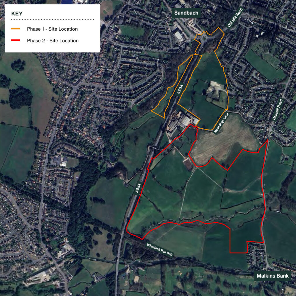
The site (Phase 2) extends to approximately 31.8 hectares of agricultural land on the southern edge of Sandbach. It is located immediately south of Houndings Lane and adjoins recently approved residential development to the north (Phase 1).
The land is bounded by the A534 to the west, Hassall Road to the east, and the Wheelock Rail Trail and Trent & Mersey Canal corridor to the south. The site is not Green Belt and is not subject to any national landscape or ecological designations.
Technical work undertaken to date confirms that the site has relatively limited constraints, with all proposed residential development located within Flood Zone 1.
Policy Context
Background and Context
Residential development has already been established in this location through the adjoining ‘Phase 1’ site, which benefits from planning permissions for up to 200 homes and associated open space.
More recently, a further planning application on Phase 1 for 204 homes has been resolved to grant permission by Cheshire East Council, subject to the completion of a S106 legal agreement.
The Phase 2 proposals represent a logical next phase of growth, designed to be planned comprehensively and delivered alongside new infrastructure, open space and community facilities.
Local Plan Review
Local planning authorities are required by Government to regularly review and update their Local Plans to ensure that they remain effective and up to date.
Cheshire East Council is currently progressing work on the preparation of a new Local Plan, which will establish the strategic planning framework for the borough and identify sites to meet future development needs over the plan period.
The emerging Local Plan will play a key role in addressing housing requirements across the District, including the need to identify sustainable locations for residential growth in settlements such as Sandbach.
Increased Housing Targets
Recent changes to national planning policy, including revisions to the National Planning Policy Framework, have resulted in increased housing requirements for many local planning authorities, including Cheshire East Council.
As a result, there is a recognised need to identify and bring forward suitable, deliverable sites in sustainable locations to help meet future housing needs and maintain a healthy supply of housing land.
The Phase 2 proposals present an opportunity to contribute positively to this requirement, delivering new homes in a manner that respects the character of the surrounding area.
The Proposals
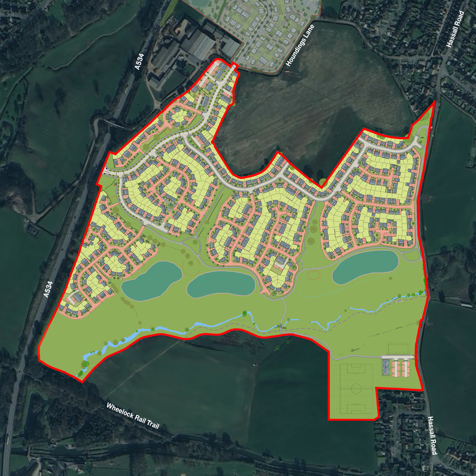
The emerging illustrative masterplan has been shaped by assessments relating to highways, ecology and landscape considerations, helping to ensure the development is deliverable, well-designed and sustainable. At this early planning stage, the plan is indicative only and may evolve as the project progresses, informed by ongoing technical work and feedback received through consultation.
Click or hover over the location markers to view
Potential location for
a Child Play Area
Potential location for
a Child Play Area
Potential location for
a Child Play Area
Potential location for
attenuation pond
designed to manage
surface water
Potential location for
attenuation pond
designed to manage
surface water
Potential location for
attenuation pond
designed to manage
surface water
All modes access from
from Phase 1
Primary vehicular access
from the A534
Public Open Space
Landscaped focal green
space to provide visual focus
and habitat corridor
Existing hedgerows to be
retained as much as possible
Retention of existing
public right of way
A mix of dwelling types, sizes and
tenures to create a balanced and
sustainable new communit
Pedestrian and
emergency access only
Active travel access
from Hassall Road
Set back form to define a tree lined
primary residential street
Circular walk routes
incorporating natural play
and wider site connectivity
Full-size adult
football pitch
Multi-Use Games Area,
and a supporting sports
pavilion with parking
Potential vehicular and
pedestrian access
from Hassall Road
Muller Property Group is proposing a residential and sports development, which will assist the Council in meeting its need to deliver sufficient homes and sports pitch provision to meet identified demand.
The current proposals are illustrated on the Masterplan Plan and include:
- The delivery of around 450 new homes in a sustainable and accessible location
- The inclusion of 30% affordable housing, delivered in line with local planning policy
- A mix of 1–5 bedroom homes, focused on meeting local housing needs
- Around 13.9 hectares of extensive areas of public open space, significantly exceeding policy requirements
- New sports and recreation facilities, including: a full-size football pitch, a Multi-Use Games Area (MUGA), and a sports pavilion
- A comprehensive landscaping strategy forming a central part of the scheme, designed to enhance visual appearance and integrate the development into its surroundings
- A network of green corridors, landscaped areas and walking routes
- Children’s play spaces and informal recreation areas
- The retention and enhancement of existing trees and hedgerows wherever possible, supporting biodiversity and landscape character
- The retention and enhancement of existing public rights of way across the site
- New and improved pedestrian and cycle connections, including links to existing routes
- Primary vehicular access from the A534, with additional connections to surrounding development
- A new spine road and supporting internal road network
- Sustainable drainage features, including attenuation areas to manage surface water and ensure no increased flood risk off-site
- Biodiversity enhancements and new tree planting, delivering at least 10% Biodiversity Net Gain
Technical Work
We have already undertaken a range of technical work on the site to inform how we design the scheme and raise any constrains we need to consider. These have been assessed through a series of initial surveys and other assessments.
Our technical work will be expanded upon within the forthcoming planning application submission, which will include the following:
- Landscape and Visual Impact Assessment
- Transport Assessment
- Ecology, Biodiversity Net Gain Analysis
- Heritage Assessment
- Tree Survey
- Ecology
- Drainage and Flood Risk
- Geo-environmental
- Agricultural Land Quality
- Air Quality
- Noise
Access and Movement
A comprehensive access and movement strategy underpins the proposals.
The primary vehicular access will be taken from the A534 to the west, supported by a secondary connection to the north via the adjoining Phase 1 development. Additional pedestrian and cycle connections are proposed to Hassall Road and surrounding routes.
A new spine road will run through the site, complemented by safe and convenient walking and cycling routes, including a footbridge linking residential areas with the sports facilities.
Public Open Space
The masterplan delivers a substantial amount of public open space, significantly exceeding local policy requirements.
While policy would require approximately 2.85 hectares of public open space, the proposals provide around 13.9 hectares. This includes:
Informal green space
Children’s play areas
Recreational walking routes
Green corridors and landscaped areas
Open space associated with drainage features
The open space will be accessible, multifunctional and designed for long-term community benefit.
Flood Risk and Drainage
The planning application will address all relevant flood risk and drainage considerations, incorporating sustainable drainage systems (SuDS) throughout the development.
Surface water will be managed on site through an integrated SuDS, including basins, swales and ponds. These features will manage runoff, improve water quality, enhance the landscape, and will ultimately discharge to an attenuation pond located within the proposals.
All residential development is located within Flood Zone 1, the lowest category of flood risk. Areas of higher flood risk are retained as open space.
Biodiversity and Trees
The proposals will deliver a minimum of 10% Biodiversity Net Gain in accordance with national requirements.
Existing hedgerows and trees will be retained and enhanced wherever possible, alongside new planting across the site. New habitats will include grassland, wetland and woodland planting, integrated with open space and drainage features.
A long-term ecological management plan will be secured to ensure lasting environmental benefits.
Agricultural Land Survey
An Agricultural Land Classification Survey was carried out to assess the quality of the agricultural land. The survey included desk-based research and on-site soil investigations and was completed in line with national guidance. The land is currently used for arable farming and grazing.
The survey found that most of the site is Subgrade 3b, which is classed as moderate quality agricultural land and is not Best and Most Versatile (BMV). A smaller area is Subgrade 3a, which is considered BMV land, and a small area of lower-quality Grade 4 land. The main factor limiting land quality is soil wetness in parts of the site, with localised effects from slope and flood risk. Overall, the majority of the land is not classified as high-quality agricultural land.
Benefits
The proposals would bring a number of benefits for Sandbach and the wider Cheshire area, including:
Affordable Housing
Enabling social mobility by providing 30% affordable homes, with a mix of affordable rent and affordable ownership.
Economic Boost
New homes to help meet local housing needs and support existing services through the creation of jobs, and opportunities for local suppliers during development, plus increased local spending once homes are occupied.
Green Space & Play Areas
Retaining trees, hedgerows and creating over 13.9 hectares of landscaped public open space for recreation, walking and community use.
Visual Enhancements
Comprehensive landscaping strategy designed to create a visually pleasing site, with safe and convenient routes linking the development with nearby amenities.
Wildlife and the Environment
Layouts and planting designed to reflect local character and enhance the environment, with a commitment to deliver a 10% biodiversity net gain on-site.
Addressing local housing need
Helping to address Cheshire East’s identified housing shortfall and support local housing needs by providing around 450 new homes.
A Range of Homes to Meet Local Needs
Supports a wide range of housing needs through the delivery of 1–5 bedroom homes for families, first-time buyers and downsizers.
New Community Sports Facilities
Delivers a full-size football pitch, MUGA and sports pavilion, responding directly to an identified shortfall in local sports provision.
Improved Access and Connectivity
Creates new vehicular, pedestrian and cycle connections, including links to surrounding development and existing routes, encouraging sustainable travel.
Frequently Asked Questions
We have addressed some common questions about our emerging proposals. We will continue to review, update and add to the FAQs as the consultation moves forward and through the planning process.
Why is this site being promoted for development?
Cheshire East has an identified shortfall in its five-year housing land supply and a significantly increased housing need. The site is located on the edge of Sandbach, adjoining existing and recently approved housing, and is well placed to help meet local housing needs in a sustainable way.
The site is not Green Belt, is not subject to national landscape or ecological designations, and can be delivered alongside new infrastructure, open space and community facilities.
How many homes are proposed?
The emerging proposals include up to approximately 450 new homes. This figure is indicative and may change as the masterplan evolves through further technical work and consultation.
What type of homes will be built?
The development will provide a mix of 1 to 5-bedroom homes, with a strong focus on 2 and 3-bedroom properties to reflect local housing needs. Homes are expected to be predominantly two and three storeys in height.
30% of the homes will be affordable housing, in line with Cheshire East planning policy.
Will there be affordable housing?
The proposals include 30% affordable housing, which will be delivered in accordance with local policy and agreed with Cheshire East Council.
What about traffic and access?
A detailed transport assessment is being prepared to understand the impact of the development on the local road network.
The primary vehicular access is proposed from the A534, with a secondary connection to the north linking into the adjoining Phase 1 development. Pedestrian and cycle connections will also be improved to encourage sustainable travel.
Any necessary highway improvements will be identified and delivered as part of the development.
Will local services and infrastructure be able to cope?
New development contributes towards local infrastructure through planning obligations and the Community Infrastructure Levy, where applicable. These contributions help support improvements to education, healthcare, transport and other local services.
Infrastructure delivery will be considered as part of the planning application process.
What open space will be provided?
The proposals include around 13.9 hectares of public open space, significantly exceeding the amount required by planning policy.
This will include landscaped green space, walking routes, play areas, recreational space and green corridors, designed to be accessible to both new and existing residents.
Will there be sports facilities?
The proposals include a full-size football pitch, a Multi-Use Games Area (MUGA) and a sports pavilion. These facilities will be available for community use and respond to an identified local shortfall in sports provision.
Is the site at risk of flooding?
All proposed residential development is located within Flood Zone 1, the lowest category of flood risk.
Areas of higher flood risk are retained as open space, and surface water will be managed through a comprehensive Sustainable Drainage System (SuDS).
How will the development affect wildlife and trees?
The proposals will deliver at least a 10% Biodiversity Net Gain, in line with national requirements.
Existing hedgerows and trees will be retained and enhanced wherever possible, alongside new planting and habitat creation across the site.
What is a hybrid planning application?
A hybrid planning application combines both full and outline planning permission.
For this site, detailed (full) planning permission is proposed for key infrastructure elements, such as site access, internal spine roads and drainage works. Outline planning permission would be sought for the residential development, sports facilities, public open space and landscaping, with details such as layout, appearance and scale to be approved at a later stage through separate reserved matters applications.
This approach allows essential infrastructure to be delivered early, while retaining flexibility to refine the detailed design of the development as the project progresses.
Have Your Say
We want to create a community that local people feel proud of, and your feedback is invaluable in shaping our plans. Please take a few moments to share your thoughts on our proposals by completing the form below.
Completing the online feedback form
Email: land@muller-property.co.uk
using the title ‘Sandbach Consultation’
within the subject line of the email.
Call: 0800 788 0900
(Monday to Friday: 9:00am to 5:30pm)
Post: Ref: Sandbach, Muller Property Group, The Point, Crewe Road, Alsager, Cheshire, ST7 2GP
Your Views Are Important To Us
Your responses will help us as we refine our plans before submitting a hybrid planning application to Cheshire East Council.
Please submit your feedback by Friday 13th March 2026.
Next Steps
The proposals will be brought forward through a hybrid planning application.
This will include:
A full planning application for key infrastructure such as site access, spine roads and drainage
An outline planning application for homes, sports facilities, open space and landscaping, supported by parameter plans and design principles
As part of the forthcoming planning application, a Statement of Community Involvement will be prepared to summarise the feedback received and explain how it has informed the proposals.
Once the application has been registered by the Council, there will be a further opportunity for residents and stakeholders to provide comments through the Council’s formal consultation process.
Consultation and Engagement
Engagement with the local community is a key part of the project. Muller Property Group is committed to ongoing dialogue with local residents and stakeholders, Sandbach Town Council, Hassall Parish Council, and Cheshire East Council.
This public consultation forms part of the pre-application process. Feedback will be carefully reviewed and, where appropriate, used to inform the final masterplan and planning application.
How We Use and Protect Your Data
Muller Property Group is committed to protecting your personal data in accordance with the UK General Data Protection Regulation (UK GDPR) and the Data Protection Act 2018.
When you contact us in relation to the proposed development or submit feedback as part of this consultation, we may collect personal information such as your name, address and email address. This information is used to review and respond to comments, identify key issues raised, and to include a summary of consultation responses within the Statement of Community Involvement (SCI).
In line with the planning process, a full copy of consultation responses, including personal details, may be submitted to the Local Planning Authority (LPA) to demonstrate who has been consulted and to ensure comments are available for consideration. The SCI may be published online by the LPA in accordance with their own data protection policies. Should the application be subject to an appeal, this information may also be shared with the Planning Inspectorate.
Your contact details may be used to inform you of future consultations relating to this site. Your data will not be used for marketing purposes and will not be shared with third parties for commercial use.
Land South of Houndings Lane, Sandbach.